
On the Western Edge of North Dakota is an area that most people wouldn't associate with the state when it comes to mind. Many will think that North Dakota is all flat and nothing but farm land. A trip across the eastern part of the state may make you think you were correct, but there is more to the state than just fields.
There is an area of Badlands that is similar to the more well known National Park in neighboring South Dakota. North Dakotas Badlands are also home to a National Park, the Theodore Roosevelt National Park. Ol' Teddy Roosevelt was a rancher in the Badlands in the late 1800's and he is known to have said that he never would have became president if it wasn't for his experiences in North Dakota. The future President had more than his fair share of adventures, and had said: "All life in the wilderness is so pleasant that the temptation is to consider each particular variety, while one is enjoying it, as better than any other. A canoe trip through the great forests, a trip with a pack-train among the mountains, a trip on snow-shoes through the silent, mysterious fairy-land of the woods in winter--each has its peculiar charm."
Long before TR came to the area, the Mandan Tribe hunted and explored the area. Once this 100 mile trail was created, they asked a Mandan elder to name it, he chose Maah Daah Hey, which means Grandfather or Something that will be around for a long time. A few years ago, a new section of trail was added and the new total mileage is 144 miles.
During the winter of 2016, I had mentioned to a couple friends that I thought we should do this trail, and do it as a Bikepacking trip where we carry all of our camping gear and supplies on the bike. After some planning and a lot of conversations, we kind of decided that none of us really wanted to drop a ton of money Bikepacking specific luggage and gear that we may not use again, or at least not much. The local bike shop in Medora North Dakota is the information hub for riding this trail, and they also offer a shuttle service. Despite them having a shuttle, we decided to try to find someone to come with us and shuttle our gear, this would allow us to ride with much less of a payload on our bikes.
All I had to do was mention the shuttle situation to Melanie and she was on-board. Maps were bought, GPS files downloaded, dates were set, gear was purchased and we had a trip planned.

We had a couple choices of vehicles to use, but when Bill offered his big truck, it was a no brainer to take that, it had the payload capacity and comfort that would make this trip more enjoyable. We loaded up and hit the road Friday night after work and drove up to St. Cloud Minnesota for the night..
Just past Minneapolis, we got on I94 West and the GPS display made us realize how long of a drive was in store for us.

We made it to Medora North Dakota early in the afternoon and headed right to Dakota Cyclery to get a couple more maps, some supplies and most importantly, local information.

Very cool shop with a great crew.

We stopped at a local convenience store to fuel up the truck and to get water and other supplies. Our plan was to head towards the northern end of the trail and camp out for the night, then start the ride early the next morning. On our way north, we were going to take a detour to the Magpie Campground which would be our second nights camp site and we would also be stopping at a few water boxes to drop off a few gallons of water so we can fill up during our ride.
Charlie the Adventure Dog, Melanie and Myself in Medora.

We headed north out of Medora on Highway 85 and on our way north, we were passed by a fire department brush truck, one of those off road capable trucks that they send out for brush fires. When we started to get closer to our turnoff on Magpie Road, we could see smoke in the distance.

There was definitely a wildfire nearby.


This doesn't look good!

We went past the campground and met a ton of fire trucks, people, ATV's etc. We turned around and decided to get out of the area. We pulled over so that I could get the photo you see below and there was a State Trooper right behind us. He asked us what we were up to, and said that with the wildfire and all of the oil drilling rigs, Pipelines and stuff in the area that it wasn't safe to be in the area and he was telling us to leave.

On our way back to the highway, something felt funny with the truck and we noticed that the rear tire was losing air. We had just driven about 30 miles of rough gravel roads in ranching and oil drilling territory, I'm sure there are lots of flats out here.

Luckily near the intersection with the highway was a truck stop. Not a lot of tourists out here, mostly truck drivers, oil field workers and ranchers. The spare tire put up a fight, but we were able to get it switched out and get back on our way.

We made it to the Bennett Campground and set up camp and prepared for our ride the following morning. Occasionally during the evening we could smell smoke and we saw a little bit of ash land on our tents, but we were a decent ways away from any fire.

We were treated to an amazing sunset.


Even the toilet had a nice view!

During the night, we were woken up by the sound of a vehicle pulling up to our camp and then lights coming on. A local Sheriffs Deputy drove through the campground and saw us there and woke us up to tell us about the fire. He said that the fire was Zero Percent contained, and was gaining in size. We were told that we were not in immediate danger where we were and didn't need to evacuate, but that we may not be able to ride all of our planned route. The officer gave us a phone number to call in the morning to find out more info.
The following morning was very nice, but it was already quite warm. I don't think we could see or smell any smoke at this point, but we called the Sheriffs office regardless. We didn't have much cellular coverage in many areas of this trail, but luckily we were able to get out a phone call. The person on the other end didn't have a ton of info but thought that we could ride the trail where we were at all the way to the Magpie Campground. The truck was loaded up with all of our gear and we headed out.
The Maah Daah Hey trail has many alternative trails to either get to campsites or just different trails than the main route. We were going to skip the very northern section of trail and would be starting on a trail called Cottonwood which would link up to the original trail.
Melanie got this photo of us heading out from the Bennett Campground and onto the Cottonwood Trail.

Roger on the trail.

Photo op after our first big climb. Left to Right, Roger, Chad and Bill.

It's always a good sign when you stop and buzzards are circling overhead!


Smoke from the Wildfire is visible in these two photos.


Melanie was driving the support vehicle and had learned a lot more than us. Since cellular service is so bad in this area, I was only able to send text messages when I was on the top of some ridges.

Originally it had sounded like we should be able to go all the way to Magpie CG. Melanie drove to Magpie only to find out that it had turned into fire HQ and was closed, along with the trail. She also ran into the shuttle driver for Dakota Cyclery and she said that she was pulling her riders off the trail.
An alternative plan was made, and we decided to have the shuttle meet us on the only road that we would be crossing which is called Beicegel Creek road. This was the only place we could easily get off the route before heading towards the Magpie Campground.
We got the bikes loaded on the truck and had to make a nearly 100 mile detour to get on the other side of the fire. We would have to go all the way back to Medora, go west a little ways and then back north. Unfortunately with the fire we would have to skip a bunch of the trail and would be missing some good riding and scenic areas including Devils Pass and the Elkhorn Crossing of the Little Missouri River.

On our detour we dropped off water at a few of the waterboxes along the way, and made our way to the Elkhorn Campground. This campground is on the other side of the river from the fire, so we should be safe. That river isn't much but luckily it seems like the wind shouldn't blow in this direction. We should be safe from the fire!

Very dry out here!

When we got to the entrance of the Elkhorn Campground, there was already tape across the trail and trail closed signs in the direction of the fire.

As you can see the trail is closed all the way to where we started the trail, so we were lucky to have gotten to ride what we did.

Nice sunset tonight, hopefully the fire stays on the other side of the river, because we are camped in a valley and the only way out would be towards the fire. Luckily, the driver for Dakota Cyclery had brought their riders to the same campground, so if the locals think its safe, I felt confident that we were too.

Another fantastic sunrise! We had to get up before sunrise and get breakfast made and camp broke down early, so that we could get on the trail before it got too hot. It was in the 90's during the day and there isn't much for shade out here.

The 3 Stooges on a road where the trail crosses. Most of these road crossings are service roads for oil drilling operations.

Fast and fun downhills are the reward for steep climbs.

Which are immediately punished by more climbing!

Melanie had some time to kill today, so she went on a hike with Charlie the Adventure Dog.

Bill was born in 1972, so he wanted to be photographed in front of the 72 mile trail marker. All of these trail markers have a turtle symbol on them. This is taken from the mdhta.com website: The symbol for the trail is the turtle. Adopted from the Lakota Sioux Indians, the turtle symbolizes patience, loyalty, determination, steadfastness, long-life and fortitude. The turtle shell symbolizes protection and its effigy is emblazoned on the posts that mark the trail.

Approaching an oil drilling area.

This is entertaining terrain, it changes so often. This section has a lot of wide open prairie, and then before you know it you are dropping into a valley or a lush woodland area, or possibly even super arid desert like terrain.

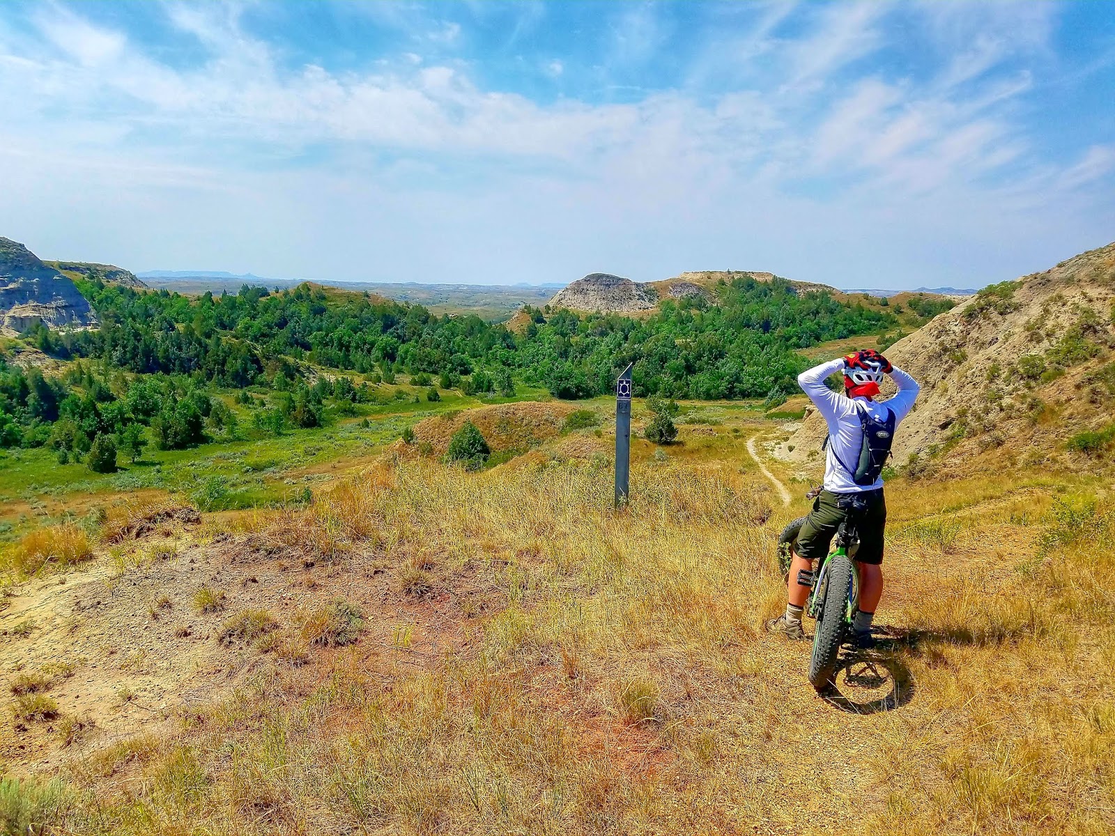
Sometimes you have to stop and take in the scenery.

Did I mention that is was hot? We had to take a break in the shade to have some snacks and recover a bit.

Another steep climb to walk up. Under most circumstances we probably could have ridden this, but the heat, fatigue and soreness added up. Plus we still had quite a ways to go!

We were getting pretty excited about getting close to our campsite!


Toward the end of today's section, we actually went through a petrified forest! Hard to see but there is a stump of an ancient petrified tree.


I was getting a little sick of sitting in the heat, and thought a drive would be nice. I'm not sure anyone else had the same feelings, but they didn't complain. We ended up driving back to Medora and getting some snacks and cooling down a bit.
It started to look really dark and stormy after supper, so we secured camp as well as we could.

We ended up getting one heck of a storm that night. The wind was pretty nuts and I wasn't sure our cheap tent would hold up, in fact it felt like it might blow away at any minute. I think that was the first time I've been camping and tried to figure out an escape plan. Like if this tent goes, what is the plan. The dog was freaking out because of all the wind and noise, so I made sure I had everything we needed handy if we had to made a run for it. Luckily, there was a sturdy looking toilet nearby that would be unpleasant but safe.
Luckily, we made it though the night OK. The next morning was nice and we were up before the sun rose and started packing up. We had about 25 miles to ride today and it was going to be another scorcher.

Before you know it, we were ready to roll again. I said goodbye to Melanie and told her we would see her this afternoon in Medora. The trail leaving the campground was fun, and after a few minutes we dropped down into a valley with a creek. It looked like this normally dry area was super wet after yesterdays storm. We had been warned about riding these trail because the Bentonite Clay would make it difficult to move.

The trail was on the other side of this creek, so we had to find a way to cross it, it looked quite deep. We ended up finding a log to cross, and with teamwork we were able to get us all across safely.

It was a beautiful morning to be riding.


Almost immediately after the water crossing, I lost my chain. My drivetrain was full of mud and the chain wouldn't stay on. We messed around with the bike for about a half an hour to get it working right. It sucked that we didn't have any cell phone service, because Melanie was probably only a short drive away and I had a spare bike.


A couple hikers stopped by and chatted a bit.

I ended up going back to the creek and dunking my bike to try to clean it up a bit.

A few more tweaks and it seemed to be working.

Off course there was hills to climb right away. The bike wasn't perfect, but I could move forward. Hopefully it wouldn't get any worse.


Luckily after a mile or two, it seemed to be working fine.

Taking a breather (and letting me catch up).

Amazing scenery.


There were a lot of these neat self closing gates along the trail.

Lots of prairie today too.

One of our water stops along the trail. We had one or two one gallon jugs of water stashed here.

We were cranking out the miles today, and were making great time.

A few technical climbs along the way.

The views were great today.


The section from Buffalo Gap to where we stopped near Medora was the best part of the trail. The trails were fast and fun.

This was the last section we rode. We dropped down to old Highway 10 and took that to
I-94. In North Dakota, you can legally ride a bicycle on the shoulder of the Interstate.

We made it back to town at around 11am and had about 25 miles in for the day.

Our total mileage was supposed to be close to 100, but due to the fire detour, we ended up with around 60 miles. While the mileage wasn't what we planned, it certainly was a great adventure. The riding was fun and challenging, the heat was pretty intense but we managed just fine with our early starts.
I would highly recommend this trail.The riding and scenery are both amazing.
I'm hoping to go back again and do the whole route.
Huge thanks to:
Melanie for putting up with us and running the shuttle vehicle for us.
Pete for loaning us the bike rack
Bluedog Cycles in Viroqua for hooking us up with cool bikes and for getting them ready for the trip.
Bill for letting us trash his truck for a week.
Bill, Roger and Melanie for coming with on this crazy adventure.